


Colorado welcomed a weekend storm that brought snow and rain across the Arkansas River Basin following a precipitous drop in early May snowpack caused by desiccating winds, low precipitation and above-average tempratures
The most recent U.S. Drought Monitor map, based on data from May 17, before the storm arrived, shows extreme drought across all of Bent County and portions of Fremont, Las Animas and Kiowa counties. The map shows Prowers and Baca counties under extreme to exceptional drought, the driest drought classification.
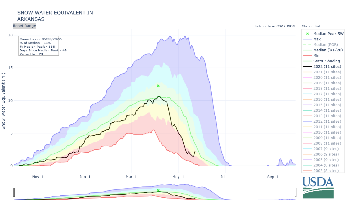
Snowpack
The National Weather Service reported the following three-day snowfall totals from the recent storm system:
- Buena Vista – 29.9 inches
- Twin Lakes – 24.8 inches
- Leadville – 24.5 inches
- Salida – 20.8 inches
- Maysville – 19.7 inches
- Cañon City – 17.2 inches
- Florissant – 11.9 inches
- Westcliffe – 10.7 inches
- Manitou Springs – 7.5 inches
- Colorado Springs – 5.4 inches
According to the National Resources Conservation Service (NRCS), the storm boosted Arkansas Basin snowpack to 66% of median as of May 23, more than double last week’s basin snowpack percentage.
Reservoir Storage
Current reservoir data from the U.S. Bureau of Reclamation shows Pueblo Reservoir is 64.7% full as of May 22 with 209,009 acre-feet of water in storage. Twin Lakes Reservoir water storage increased to 105,150 acre-feet, 74.6% of full. With Turquoise Lake receiving Fryingpan-Arkansas Project imports, water storage has increased to 69,266.3 acre-feet, or 53.5% of full, up from 44.8% a week ago. U.S. Army Corps of Engineers data show 29,625 acre-feet of water currently stored in John Martin Reservoir.
River Flows
Arkansas River flows, fed by spring runoff, continue to increase. Flows are 170 cfs near Leadville, 606 cfs below Granite and 892 cfs at the Wellsville gauge, which reported a peak flow of 1,620 cfs May 20.
The Cañon City gauge currently reports 1,060 cfs, the same as last week; however, river flow at Cañon City reached 1,750 cfs May 21. Flows are currently 1,690 cfs below Pueblo Dam and 2,330 cfs near Avondale.
At the Rocky Ford gauge, the river is flowing at 1,840 cfs. Below John Martin Reservoir, flows are 598 cfs. The gauge at Lamar is reporting 53.5 cfs.
River Calls
Currently, the Arkansas Basin has 13 active calls. The three calls on the mainstem remain unchanged from a week ago – the 1887 Amity Canal water right, the 1889 X-Y Irrigating Ditch right and the 1949 Arkansas River Compact.
The most senior calling right is the Titsworth Ditch on Fourmile Creek with an 1861 priority date. The 1866 Gonzales Ditch continues to call for Apishapa River water, and the Hoehne Ditch, with an 1865 priority, has a call on the Purgatoire River.
The Spanish Peaks Ditch (1873 priority) now has a call on the Cucharas River, and the Upper Huerfano No. 2 (1869 priority) has a call on the Huerfano River. New this week is a call on Wahatoya Creek, a tributary of the Cucharas River, by the R.B. Willis Ditch.
The new NOAA three-month temperature and precipitation outlook shows a 70-80% probability for above-average temperatures and a 33-40% likelihood of below-average precipitation across the Arkansas Basin for June, July and August.
The Arkansas River Report is provided by the Arkansas River Watershed Collaborative.