By fallowing its Lake Ranch property, the Upper Arkansas Water Conservancy District could provide 250 acre-feet of water for other uses.
At the district’s recent board meeting, engineer Wendy Ryan of Colorado River Engineers reported the findings as part of an analysis of the district’s Lake Ranch Multi-Use Project.
District General Manager Terry Scanga suggested the best way to manage the water would be to grow crops for five years then fallow the Lake Ranch acreage for one to two years.
During years that the acreage would lie fallow, the Upper Ark District could lease 250 acre-feet of water to other water users or use the water for purposes other than irrigation.
The conservancy district owns Lake Ranch, located north of Poncha Springs, and 21.9 percent of the Cameron Ditch water rights. That percentage provides irrigation water for the ranch.
While fallowing Lake Ranch offers potential benefits for meeting future water needs in the Upper Arkansas Valley, the district must meet several requirements in order to realize those benefits. The most significant requirements involve return flows from the historical irrigation of Lake Ranch.
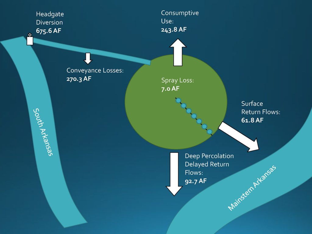
On average, Ryan reported, the district’s Cameron Ditch rights have historically yielded 675.6 acre-feet of water per year. Of that total, preliminary calculations show that 270.3 acre-feet are lost as the water flows through the ditch. Since most of that water seeps into the ground, that amount of water would need to continue to flow through the ditch to avoid lessening return flows, which would likely injure other water rights.

Ryan’s calculations also demonstrate that 92.7 acre-feet of the district’s water rights have historically percolated into the aquifer as “delayed return flows.” An additional 61.8 acre-feet of Lake Ranch water qualify as “surface return flows.”
Ryan said historical consumptive use – water used by crops – comes to an annual average of 243.8 acre-feet. An additional 7 acre-feet per year is “spray loss” from the center-pivot irrigation system and would be available when the ranchland is fallowed. So fallowing Lake Ranch would provide the Upper Ark District with an average of 250.8 acre-feet of water for that year.
Ryan said “recharge pits” could be created in the corners of Lake Ranch outside the perimeter of the center-pivot irrigation system. These pits would allow water to percolate into the aquifer as delayed return flows.
To meet surface return-flow requirements, an augmentation station would be needed to send water back to the South Arkansas River. Lake Ranch surface return flows have historically gone to the Arkansas River, but the district does not have an easement that would allow the water to return to the Arkansas.
Since putting that 61.8 acre-feet of water in the South Arkansas River would return the water to the Arkansas River downstream from the historical return flows, Ryan said the district might need to exchange water upstream to avoid potential legal opposition to Lake Ranch fallowing due to possible injury to the Salida Whitewater Park’s recreational in-channel diversion.
Finally, the district’s Cameron Ditch water is decreed for irrigation so, as Ryan noted, the district would need to change the use of the water in Water Court in order to use the consumptive use credits for a different purpose – adding the water to the district’s augmentation portfolio, for example.


