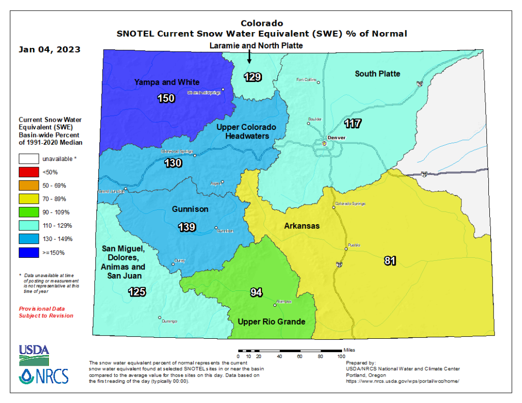
The Arkansas River Watershed Coalition’s latest River Reports shows December brought above-average snowpack to most of Colorado, but Arkansas River Basin snowpack remains low at 81% of median, up from 76% a month ago.
As of Jan. 3, 40% of Colorado was no longer experiencing drought conditions, according the Jan. 5 U.S. Drought Monitor report. However, severe drought persists across parts of the lower Arkansas Basin with extreme drought continuing in the southeast corner of the basin in Colorado.
Snowpack
Snowpack Telemetry (SNOTEL) sites relevant to the upper Arkansas Basin show snowpack near or above median, but the numbers drop off in the southern basin headwaters region.
The Saint Elmo SNOTEL site reports 127% of median for snow-water equivalent (SWE). At Brumley, near Independence Pass, the current SWE reading is 93%, and Glen Cove, north of Pikes Peak, is at 108%.
Fremont Pass stands at 94%, but nearby Buckskin Joe in South Park reads 62%. In the Sangre de Cristo Range, Hayden Pass shows 49% of median.

Reservoir Storage
Water storage in Pueblo Reservoir increased from 184,866 acre-feet to 195,933 during December, bringing the largest Fry-Ark Project reservoir to 60.7% full. Turquoise Lake, currently 64.9% full, experienced a slight monthly decline of 511 acre-feet to 83,941.2.
At Twin Lakes, storage levels also decreased in December, from 114,014 acre-feet to 105,754 acre-feet or 75% full. The U.S. Army Corps of Engineers reports water storage in John Martin Reservoir, which is used to store water for the Winter Water Storage Program (WWSP), increased to 23,462 acre-feet at the end of December, up from 15,921 acre-feet at the end of November.
River Flows
Arkansas River flows generally decrease during Colorado’s winters, and ice limits the effectiveness of gauges in the upper parts of the basin, like the gauges near Leadville and below Granite, which are not reporting new data.
The gauge at Wellsville, near Salida, reports 279 cfs and ice. The gauge at Cañon City reports 322 cfs, and the flow below Pueblo Reservoir has increased to 106 cfs.
River flow near Avondale is 280 cfs, almost unchanged from a month ago, while the flow at Rocky Ford has doubled to 141 cfs. Flow has dropped to 0.23 cfs below John Martin Reservoir but has increased to 19.4 cfs near Lamar.
Calling Water Rights
Eight water rights are currently calling for water in the Arkansas Basin. Additionally, the Maria Stevens Reservoir has an authorized diversion in place with an 1887 priority date. The most senior calling right is the 1862 Chilili Ditch, which began calling for Purgatoire River water Dec. 30, 2022. Otherwise, with the WWSP in effect, calling water rights remain unchanged from a month ago:
- Gonzales Ditch, 1866, Apishapa River.
- Coleman Ditch, 1867, Hardscrabble Creek.
- Fernandez Ditch, 1868, Turkey Creek.
- Upper Huerfano No. 2, 1869, Huerfano River.
- Doris Ditch, 1870, Fourmile Creek.
- Fort Lyon Storage Canal, 1910, Arkansas River mainstem.
- Arkansas River Compact (with Kansas), 1949, Arkansas River mainstem.


