

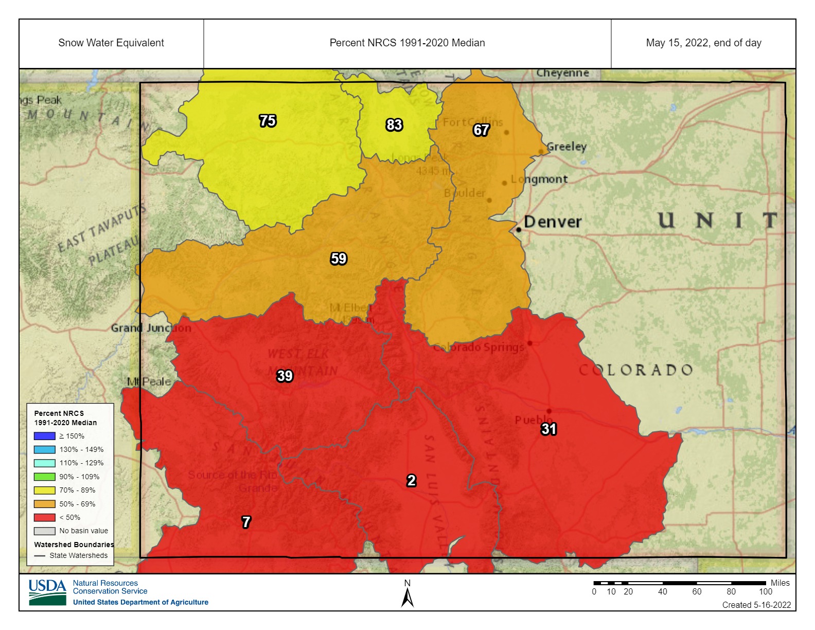

Recent weather patterns have proven detrimental to the water outlook for the Arkansas River Basin with warm temperatures, minimal precipitation and high winds combining to reduce snowpack to 31% of median.
Snowpack in the Rio Grande and San Juan basins is alarmingly low at 2% and 7%, respectively. The most recent U.S. Drought Monitor map shows little change across Colorado with moderate to severe drought conditions in most of the Arkansas Basin. However, a new area of extreme drought has developed in the lower South Platte Basin.
The new NOAA three-month temperature and precipitation outlook, updated monthly, should be available next week.

According to the National Resources Conservation Service (NRCS), “Analysis may not provide a valid measure of conditions” at almost all basin SNOTEL sites. An exception is the Fremont Pass site, which reported 73% of median snowpack as of May 16.
Reservoir Storage
Current reservoir data from the U.S. Bureau of Reclamation shows Pueblo Reservoir is 66.4% full as of May 15 with 214,378 acre-feet of water in storage. Twin Lakes Reservoir is 68.4% full at 96,403.5 acre-feet. Turquoise Lake is currently 44.8% full and stores 57,995.4 acre-feet of water.
U.S. Army Corps of Engineers data show 33,163 acre-feet of water currently stored in John Martin Reservoir, and Colorado Parks and Wildlife officials announced that John Martin Reservoir State Park’s west boat ramp closed May 16 due to low water.
River Flows
Arkansas River flows have increased as early snowmelt runoff feeds upper basin tributaries. Flows are 260 cfs near Leadville, 382 cfs below Granite, 1,120 cfs at Wellsville and 1,060 cfs at Cañon City. Below Pueblo Dam and near Avondale, flows are 736 cfs and 1,180 cfs, respectively. Flows are 690 cfs near Rocky Ford and 567 cfs below John Martin Reservoir. At Lamar, flows are currently 51.4 cfs.
Voluntary Flow Management Program
Flow management targets to support the Arkansas River fishery ended May 15, and releases from upper basin reservoirs to support recreational boating are slated to begin July 1.
River Calls
Currently, the Arkansas Basin has 15 active calls. Three calls are on the mainstem – the 1887 Amity Canal water right, the 1889 X-Y Irrigating Ditch right and the 1949 Arkansas River Compact, which dictates flow at the Colorado-Kansas state line.
The most senior calling right is the French Ditch Diversion with an 1861 priority date on French Creek upstream from Manitou Springs, and the 1866 Gonzales Ditch right continues to call for Apishapa River water.
Other tributary calls are the Lake Miriam Ditch on the Cucharas River, the Chilcotte Ditch on Fountain Creek, the Canon Heights Ditch on Fourmile Creek, the DeWeese Dye Ditch on Grape Creek, the Hayden Supply Ditch on Greenhorn Creek, the Harrington Ditch on Hardscrabble Creek, the Sefton Ditch on the Huerfano River, the Spring Ditch on Middle Tallahassee Creek, the Hoehne Ditch on the Purgatoire River and the Waggoner Ditch on Stout Creek. Priority dates for these water rights range from 1864 to 1884.
The Arkansas River Report is provided by the Arkansas River Watershed Collaborative.