

The Arkansas River Watershed Collaborative’s River Report for May shows distinct improvements in drought conditions water resources.
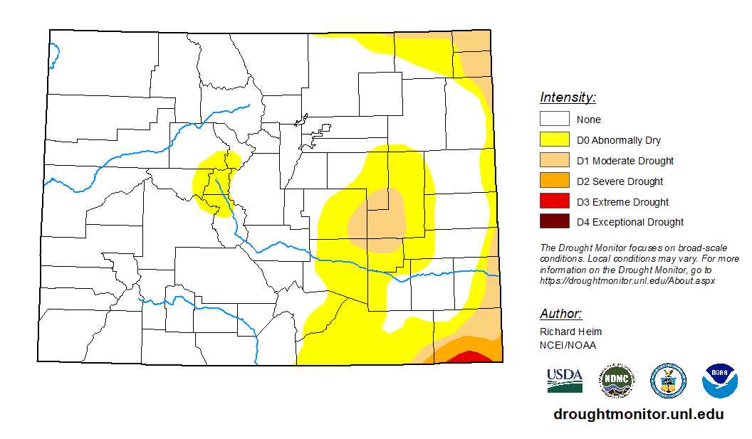
The U.S. Drought Monitor shows shows more than three-quarters of Colorado now free from drought but with some drought conditions lingering in the Arkansas River Basin.
The National Weather Service three-month outlook predicts above-normal temperatures for June through August and “equal chances” for normal precipitation for most of Colorado.
Snowpack
During May, Arkansas Basin snowpack improved from 78% to 107% of median for snow-water equivalent, but that number is suspect since most SNOTEL stations in the Ark Basin are not reporting any snowpack. The Fremont Pass SNOTEL station currently reports 91%. Nearby, the Buckskin Joe station in the Mosquito Range reads 250%.
Reservoir Storage
The Bureau of Reclamation reports that Pueblo Reservoir water storage dropped from 215,988 acre-feet at the end of April to a current level of 207,515 acre-feet (64.3% full).
In Upper Ark reservoirs, Snowmelt combined with West Slope water imports raised water levels. Water stored in Turquoise Lake increased by more than 40,000 acre-feet in May to 98,766 acre-feet (75.4% full). Twin Lakes Reservoir levels also increased, from100,055 acre-feet to 110,106 (78.1% full).
John Martin Reservoir levels are at 30,292 acre-feet, according to the latest data from the U.S. Army Corps of Engineers.
River Flows
The Arkansas River flow near Leadville reached 402 cfs May 30 but has decreased to a current reading of 248 cfs.
Just downstream, the Bureau of Reclamation releases from Twin Lakes are at 1,000 cfs, almost all of which is native Ark Basin water. As a result of these releases, river flow at the gauge below Granite is at 1,740 cfs, and the Wellsville gauge near Salida reports 2,250 cfs.
The flow at Cañon City is currently 2,590 cfs. Below Pueblo Reservoir, flows are 2,180 cfs. Near Avondale the river is flowing at 2,550 cfs, and the gauge at Rocky Ford reads 1,240 cfs.
The current reading below John Martin Reservoir is 598 cfs, and the Lamar gauge reads 66.7 cfs following a spike to 102 cfs on May 30.
Calling Water Rights
Ark Basin calling water rights have decreased from 17 a month ago to 10 currently. The most senior calling right is the 1863 Widderfield Combined right on the Apishapa River, followed by Tremayne Ditch No. 1 with an 1871 water right on West Fourmile Creek.
The Drury Ditch is calling for Hay Creek water under its 1872 right, and Westall Ditch on Fourmile Creek is calling for water to satisfy its 1875 right.
The Garden Park Ditch has an 1880-priority authorized diversion on Fourmile Creek. The Echo Ditch also has an authorized diversion (1891 priority) on Echo Creek.
Remaining calling water rights are:
- Pulaski Ditch, 1883 priority, Purgatoire River.
- Riggs Ditch No. 3, 1884, Barnard Creek.
- Colorado Canal, 1890, Arkansas River.
- Lamar Canal, 1890, Arkansas River.
- Arkansas River Compact (with Kansas), 1949, Arkansas River.