

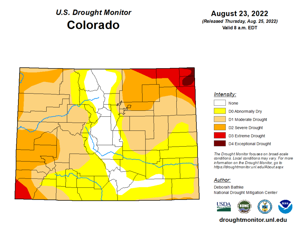
In it’s weekly River Report, the Arkansas River Watershed Collaborative notes that precipitation from the current weather pattern continues to ease drought conditions in Colorado, with over 12% of the state no longer experiencing drought, including the eastern half of Chaffee County.
Precipitation
The CoCoRaHS (Community Collaborative Rain, Hail and Snow) Network reports the following precipitation amounts for the past week:
- Leadville – 0.33 inch.
- Buena Vista – 0.54-1.59 inches.
- Salida – 1.22 inches.
- Westcliffe – 0.30-1.06 inches.
- Cañon City – 0.18 inch.
- Walsenburg – 0.52 inch.
- Trinidad – 0.41 inch.
- Pueblo – 0.01 inch.
- Colorado Springs – 0.14-0.94 inch.
- Rocky Ford – 0.02 inch.
- Pritchett – none.
- Lamar – none.
For the current water year, the August report from the Governor’s Water Availability Task Force indicates Colorado is still 1.75 inches below the long-term average for precipitation.
Reservoir Storage
Water storage in Pueblo Reservoir remains little changed this week – 184,178 acre-feet, or 57% full – according to data from the U.S. Bureau of Reclamation.
Water storage in Turquoise Lake decreased to 97,904.2 acre-feet or 75.7% full while the water level in Twin Lakes increased to 106,773 acre-feet, also 75.7% full.
With Voluntary Flow Management Program targets for recreational boating done for 2022, the Bureau of Reclamation Thursday reduced releases from Twin Lakes to the minimum 15 cfs outflow. Data for John Martin Reservoir is not available at this time.
River Flows
In the upper Arkansas River, flows near Leadville declined to 52.7 cfs this week, while the gauge below Granite currently registers 274 cfs. The flow at the Wellsville gauge is 440 cfs with an almost identical flow of 444 cfs at Cañon City.
The river flow below Pueblo Reservoir has dropped to 258 cfs, and the gauge near Avondale reports 408 cfs after peaking at 860 cfs this past week. The gauge near Rocky Ford reports 73.6 cfs after peaking at 217 cfs Monday.
The current flow is 82.4 cfs below John Martin Reservoir, but the flow held steady at a high of 256 cfs Saturday through Monday. The gauge at Lamar currently reports 27.6 cfs after spiking to 94.5 cfs just before midnight Monday.
River Calls
The Arkansas Basin currently has 15 calling water rights, including the usual number, four, on the mainstem: the Catlin Canal (1884 priority), the Lamar Canal (1886), the X-Y Irrigating Ditch (1889) and the Arkansas River Compact call at the Kansas state line.
The most senior calling water right is the Tom Wanless Ditch (1864) on Fountain Creek at its confluence with the Arkansas River. Next in seniority is the Gonzales Ditch (1866) on the Apishapa River, followed by the Coleman Ditch (1867) on Hardscrabble Creek and the Pulaski Ditch (1868) on the Purgatoire River.
Additional calling water rights include the Adams Ditch (1869) on Fourmile Creek, Hill Ditch (1873) on Howard Creek, the Cottonwood and Maxwell Ditch (1874) on Cottonwood Creek, the Marmaduke Ditch (1878) on Stout Creek, the Dotson Ditch No. 1 (1881) on the St. Charles River, the Hoosier Ditch (1882) on the North Fork of the South Arkansas River and the JM Murray Ditch (1887) on Muddy Creek.
The Arkansas River Watershed Collaborative is the nonprofit organization for the Arkansas Basin Roundtable. Formed by the Colorado General Assembly, this group of water managers and stakeholders works to find solutions to water-related issues in the basin. Some Roundtable members serve as the ARWC Board of Directors.